SMUB is my 4×4 skid-steer rover: a Livox Mid-360 and a forward Mid-70, a Jetson Xavier AGX, ROS 2 Jazzy. I want it to drive to a goal a few hundred metres away over rough ground without rolling over, and to handle structures with more than one level: under a bridge, past an overhang, up the ramps of an underground car park. Since late September I’ve built and benchmarked a navigation stack for that in simulation. The latest version reaches 69 of 80 held-out off-road goals and all 12 goals 120–200 m away, with no falls in 112 benchmark runs, and it found its way round a hill in a world built from a real place.
It has not driven the real robot yet. Every number on this page comes from Gazebo with perfect odometry. Most of the page is about the bugs I found on the way, because each one was found in a recorded run, not by tuning.
Reached: simulation only. Next: real-robot bag replay, then the Xavier, then the field.
Simulation, not the robot. Same episode twice. Left: the route flips behind the rover, it turns in place at a trench edge and rolls to 37°. Right: with the turn guard it backs away first, goes round the trench's far end and arrives.
The goal
Four things I wasn't willing to give up:
Range. Goals hundreds of metres away, not just across the room.
Multiple levels. Bridges, overhangs and car-park floors, where "the ground at x, y" has more than one answer.
Dead-end memory. A route that turns out to be blocked should stay blocked.
Planning that scales. The cost per plan shouldn't grow with how far the robot has driven.
And one rule on top: it should get stuck before it falls over.
What I built
Mid-360 + Mid-70Point clouds, 10 Hz each.
→
lgridRolling height grid, up to 3 surfaces per cell. The drivable one is connected to the robot.
→
TraversabilitySlope, step and edge rules, giving an obstacle map.
→
Goal relayGrid planner by default. Goal on another floor: FAR multi-level, then TARE if FAR has no route.
→
Local plannerCMU local planner and path follower.
→
Stall / turn guardThen wheel commands.
I started from the CMU autonomy stack: a local planner that picks among precomputed paths, FAR (a route planner on a visibility graph) and TARE (an exploration planner). The local planner and path follower stayed. The rest changed:
A terrain map with several surfaces per cell ("lgrid"). It's a rolling height grid around the robot, built on the CPU from both lidars. Each 0.2 m cell keeps up to three surfaces, and the drivable one is chosen by what's connected to where the robot stands. A bridge deck or the floor above never becomes the ground.
A grid route planner. Dijkstra on a traversability map, replacing FAR for off-road driving. It started as a fixed 120 m square and became unbounded: map tiles that exist only where something was seen, a fine window that follows the robot, and a coarse cost-to-go beyond it.
A safety layer. A stall guard that backs off when the robot hangs tilted, a guard against turning in place next to a trench edge, and dead-end memory.
A hybrid hand-off. The grid planner drives by default. When the goal is on another floor, FAR, which has a multi-level mode, takes over, and TARE explores if FAR has no route.
What I borrowed
The CMU autonomy stack (local planner, path follower, FAR, TARE), elevation_mapping_cupy as an alternative terrain backend, and Gazebo Harmonic. Written for this project: the lgrid terrain map, the traversability rules, the grid planner and its unbounded version, the goal relay that switches planners, the stall and turn guards, dead-end memory, the benchmark harness and the world generator.
The benchmark
I built a harness before changing anything, because without one every fix is a guess.
Worlds. Procedural 80 m heightmaps with trenches, plateaus and mounds of varying steepness, plus single-feature test worlds and a set of garage, bridge and overhang courses. A long-range tier uses 320 m worlds with routes of 120–200 m.
Ground truth. The same heightmap Gazebo simulates gives the true reachable set and the optimal route length. Success means ending within 1.5 m of the best reachable point, not just "near the click".
A held-out set of 40 episodes I never tuned on.
Paired comparisons. Every config runs the same episodes, and I compare pairs, not averages.
Recorded runs. A bag of every failure I looked into. Every bug below was found in one of them.
Results
All simulation, ground-truth odometry. "Held-out" is 40 episodes × 2 repeats unless noted. A run that falls is not a success; falls are also counted separately.
Stack
Off-road held-out
Long range (12)
Garage / bridges (10 × 2)
Starting point: CMU planner + FAR on an elevation map, before fixes
23/40, 2 falls (1 repeat)
not run
not run
lgrid + grid planner
74/80, 0 falls
10/12
can't: single-layer
lgrid + FAR + TARE
64/80, 0 falls
12/12
16/20
Hybrid, Sep 29
71/80, 0 falls
11/12, 1 fall
14/20
Hybrid with slope-aware planning, Oct 8
69/80, 0 falls
12/12, 0 falls
16/20
Off-road, the grid planner beats FAR: of the episodes where they disagreed, the grid planner won 12 and FAR won 2 (p = 0.013). The hybrid is the only stack that covers all three columns. With the slope-aware planner (Oct 8), it matches the grid stack off-road within noise, reaches every long-range goal with no falls, and does better in the garage. Across the 112 regression runs, nothing fell.
Simulation. Under a bridge deck 3.0 m up. The orange outline is the deck; the robot's own map never makes it the ground.Simulation. A beam 1.1 m up: it drives under.Simulation. A beam 0.45 m up is lower than the robot, so it goes round.
Log
A benchmark before any fixes
I wrote the world generator and the harness first. The starting point, the CMU local planner and FAR on elevation_mapping_cupy terrain, reached 23 of 40 held-out goals and fell twice. The failures had names: spinning in place, driving off a ridge, and FAR silently dropping goals it had no path to.
A grid planner instead of FAR
FAR plans on a visibility graph and kept routing across trench floors it had never seen. A Dijkstra planner on the traversability map, with a stall guard, took the elevation-mapping stack from 23 to 37 of 40 overnight (one repeat).
Rolled over turning around
On one held-out episode the route flipped behind the robot, and it turned in place at a trench edge. A rear wheel went over and it rolled to 37°. I added a guard: before turning in place next to a flagged edge, back off; with no room behind, hold. The first version held forever and stranded the robot, so the hold now ends after 5 s, and the turn is stopped if the robot tilts past 12°. The same episode afterwards: no falls in 16 runs. It's the clip at the top of this page.
The map walled the robot in on slopes
My own terrain map trailed elevation_mapping_cupy by about 17 points: 59 of 80 runs against 72 of 79. Recorded runs showed why. Under the robot, where the lidars can't see, the map wrote a flat disc at the robot's height. On a 16° slope that disc ends in a 0.24 m step all round the robot, over the 0.18 m limit. The robot was boxed in by its own footprint. Tilting the disc to the robot's attitude fixed two episodes that had failed every time, 0 of 4 to 4 of 4.
A second recorded fall showed the disc was also overwriting real ground the lidars had seen on the way in. The map under the robot was its own tilt echoed back. Now the disc only fills cells that were never observed. Held-out went from 30 to 37 of 40.
The map under the robot was its own attitude echoed back.
Simulation, before the fix. Left: elevation_mapping_cupy reaches the goal. Right: my map stops the rover in open ground on a slope; the map under it was a flat disc. After the fix this episode went 2 for 2.
A pose-based planner that lost
I built a planner that judges the robot's body instead of map cells: at every cell and 16 headings it places the four wheels on the terrain and computes roll, pitch, a hanging wheel and belly clearance. It found both map bugs above. As a driver it was worse: 31 of 40 with 3 falls, against 37 of 40 with none. It stays in the code, switched off.
Planning at any range
The grid planner was a 120 m square centred on the start, so any goal past about 60 m was clamped to its edge. A dense grid also gets slow fast: 0.1 s per plan at 120 m, 1.7 s at 400 m on a desktop. I split it into tiles that exist only where something was seen, an 80 m fine window that follows the robot, and a coarse cost-to-go from the goal. A plan now takes about 50 ms for a goal 1 km away.
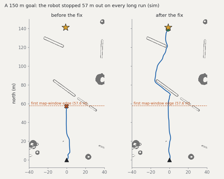
Stranded 57 m out
Most failed long-range runs of the grid stack stopped in open ground about 57 m from the start. 57.6 m is the edge of the planner's first window. My route hysteresis kept the old route as long as it was "about as good", and continuing from its end at the old window edge always looked exactly as good. It got trimmed down to the robot's own position, and the robot stopped. Now an old route is kept only while it still reaches the current window edge. Long range for the grid stack went from 6 to 10 of 12.
Simulation, a 150 m goal. Left: before the fix the robot stops at the edge of the planner's first window. Right: after.
Every hill was another floor
FAR and TARE reached 0 of 12 long-range goals. The goal relay counted any height difference over 1 m as a different floor, at any distance, and handed the run to the explorer. On a real hillside a goal 150 m away and 3 m higher would do the same. The tolerance now grows with horizontal distance: 1 m close by, 18 m at 100 m. FAR and TARE went to 11 of 12, then 12 of 12.
A step smeared into two harmless ones
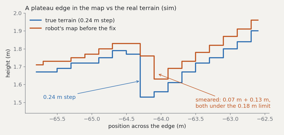
Two long runs rolled over at the same kind of place: a small, steep mound ending at a 0.28 m plateau edge. The map had flagged the edge from a distance, then lost the flag as the robot got close. The cause was a timer. The map merges hits that arrive within 0.5 s, keeping the highest point, but the timer reset on every hit, and both lidars hit a visible cell every 50–100 ms. The merge never ended, and stray hits from the top of the step settled in the cell below for good. A 0.24 m step became 0.07 m plus 0.13 m, both under the limit. Now the window runs from its first hit.
A cell seen every 0.1 s never restarted: its top became the running max since it came into view.
Simulation. A 0.24 m plateau edge in the real terrain (blue) and in the robot's map before the fix (orange).
Hybrid
On the off-road set the grid planner beat FAR, 74 to 64 of 80, but it can't do floors. The hybrid lets it drive and hands over to FAR only when the goal is on another floor, and only if the map doesn't already show ground at the goal's height. After FAR and TARE handed the robot back and forth 60 times in one run, mode changes are capped at 8 per goal. When the robot makes no progress for 15 s, the next stretch of route is marked as a dead end. Result: 71 of 80 off-road, 11 of 12 long range, 14 of 20 garage.
Still open
The remaining falls, about 1% of runs, cluster on one feature: a steep mound meeting a plateau edge in one long-range world. I made three fixes aimed at it, and each fixed the case I diagnosed. It still falls occasionally nearby. At this rate, telling 1% from 2% apart takes several hundred runs per config.
A real place
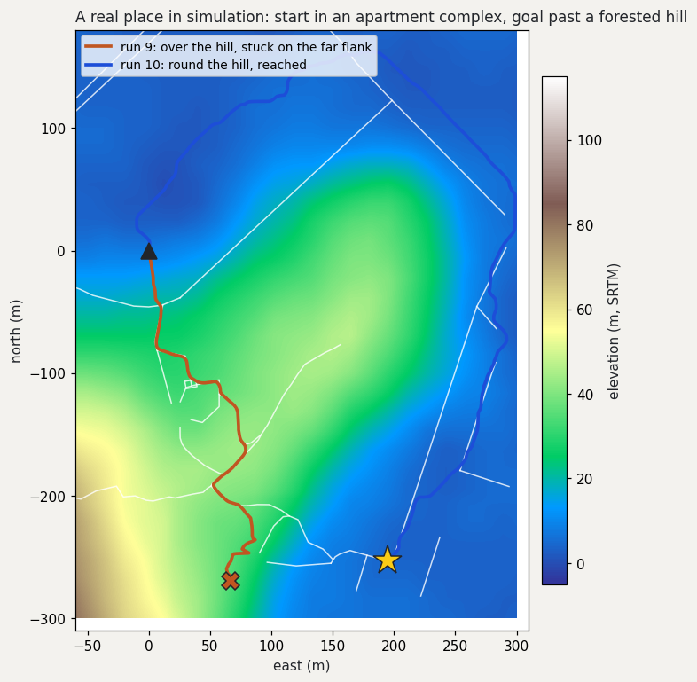
Procedural worlds only test what I thought to put in them, so I built a world from a real place: a hillside park near Yangsan, with buildings, roads and footpaths from OpenStreetMap, real elevation from SRTM (114 m of relief), and 5,300 tree trunks. OpenStreetMap maps no trees there, so the trunks are my assumption. The goal was 320 m away, past a forested hill. The start point turned out to be inside a 31-storey apartment tower in the map, so I moved it 5 m to the open ground outside. Nine runs failed before one worked.
The map was 3D, the planner wasn’t
The terrain map already stored real heights, but both planners reduced each cell to “obstacle or not” and planned on a flat plane. A 19° slope taken head-on and the same slope taken sideways looked the same, though only one of them rolls the robot. The route went straight over the hill and boxed itself in on a side slope. Now every planned move gets a pitch along it and a roll across it from the height gradient. Moves past 20° of roll or 25° of pitch are forbidden, steeper moves cost more, and uphill costs extra.
Unseen ground counted as flat
The slope costs only applied where the robot had already seen the ground, so the planner preferred ground it hadn’t seen, which here was the steepest part of the hill. I gave it a prior elevation map, so it knows the slopes before seeing them. In the simulator that prior is the true terrain, so this is the optimistic case.
A tie on a hilltop
On top of the hill the robot spun in place for minutes; at one point its heading went through a full 360° in 16 s. Two routes cost almost the same: down the far side, or back the way it came and around. Each small movement flipped the choice. I tried four fixes in turn: a time-based hold, a dead band on the planning window, committing to a target cell, and committing to a direction. Each fixed the case in front of me, and the next run found the next gap.
The real cause was one layer up
I stopped watching runs and asked a simpler question offline: does any route to the goal exist under the slope limits? One did, 432 m long, east along the contour and round the shoulder of the hill. The robot had never tried it. The planner’s 80 m window around the robot applied the limits, but its long-range layer only added a general steepness penalty. That layer kept pointing the robot at a descent the limits forbid, and the window only found out on the hilltop. With the same direction-aware limits in both layers, run 10 went round the hill on the roads and reached the goal with no stalls or rollovers.
Simulation, a real place: run 10 with slope-aware planning goes round the forested hill on the roads and reaches the goal 320 m away, in 847 s of sim time shown at 85×. Faint orange: run 9, which went over the hill and stuck on the far flank.Simulation, a real place: the Yangsan route. Run 9 (orange) went over the hill and stuck on the far flank. Run 10 (blue) went round on the roads and reached the goal. White lines are mapped roads and paths.
Did it cost anything elsewhere?
I re-ran the whole benchmark. My first limits, 15° of roll and 22° of pitch, were stricter than the benchmark’s 25° notion of drivable, and two held-out episodes timed out on long detours. At 20° and 25° one of them recovered. The other had its goal on top of a steep mound, and the robot circled the mound looking for the strictly nearest reachable spot; it now takes the cheapest of the nearly-nearest spots. Final regression: 69 of 80 off-road (71 before, within noise), 16 of 20 in the garage (14 before), 12 of 12 long range (11 and a fall before), and no falls in 112 runs.
Things I checked that didn't matter
Tilting the Mid-70 down 20°. It sees the ground from 0.29 m ahead instead of 0.66 m, with 25% more ground points within 1.5 m. Success didn't change: 69 against 70 of 78 off-road pairs, 17 against 17 of 20 on the garage set. I'll print the tilted mount anyway; real grass close in front is where near-field coverage should matter more.
A faster ROS executor. Not a success-rate change but a compute one: switching the Python nodes to rclpy's EventsExecutor cut the stall guard from 33% to 9% of a desktop core. The Xavier is roughly three times slower per core.
Limits and next steps
Simulation only, with perfect odometry. No FAST-LIO drift, no lidar noise from dust or grass, no real skid-steer friction. Read the numbers as rankings, not field predictions.
Garage upper levels are the weakest case: the explorer tends to declare the job done early.
The slope limits are estimates. The 20° roll and 25° pitch limits come from the model. The real robot’s limits need measuring.
The prior elevation map is perfect in sim. On the robot it would come from a real elevation model, such as Korea’s national 5 m DEM, and be less exact.
One held-out episode scores as stuck. Its goal is 0.6 m from a steep step. The benchmark counts that spot as reachable, but my planner keeps more distance from the step and stops 1.6 m from the goal, just outside the 1.5 m scoring radius.
Untested: people and moving obstacles, rain, night.
Next: replay real-robot bags through the perception stack; profile the whole stack for the Xavier, whose JetPack tops out at Ubuntu 20.04, so ROS 2 Jazzy runs in Docker; 3D-print sensor mounts that match the simulated ones exactly.
As with the A1 work, the code was written in Claude Code sessions I directed. I set the goals and the bar for success, chose what to test, and read the failures.